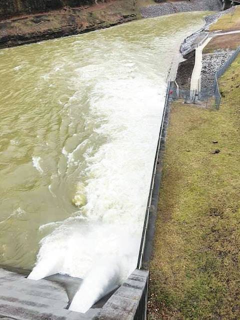
Caution urged to those visiting Martins Fork Dam
Published 9:49 am Friday, February 22, 2019
Courtesy of U.S. Army Corps of Engineers
Visitors were urged to use caution when visiting the Martins Fork Dam tail waters and fishing areas where more water than normal is being discharged due to high water.
The U.S. Army Corps of Engineers Nashville District is continuing to monitor stream conditions throughout the Cumberland River Basin and to manage the release of water from its 10 dams as heavy rain continues to impact the region this week.
The basin has received two to five inches of rain over the past four days, four to seven inches of rain over the past seven days, and seven to 12 inches of rain over the past month. The latest forecast from the National Weather Service called for three to four inches of rainfall on Thursday through the next 72 hours.
On Wednesday, the Smith Recreation Area and Boat Ramp at Martins Fork Lake were closed due to high water levels until further notice.
The public was urged to use caution when visiting the Martins Fork Dam tail waters and fishing areas on Thursday where more water than normal is being discharged due to high water.
The lake elevation is 1,324.72 and the winter pool target elevation is 1,300. A total of 51 percent of the flood control pool is currently being utilized. Current discharge is about 1,150 cubic feet per second and the lake elevation is falling.
With additional rainfall, the lake will more than likely rise some. The crest elevation for the uncontrolled spillway is 1,341. The pool of record is 1,331.63.
Martins Fork is fed from two primary sources, Martins Fork and Cranks Creek, which meet in the upper end of the lake. Below the dam, Martins Fork flows in a northerly direction to Harlan, where it joins the Clover Fork, which then joins the Poor Fork to form the Cumberland River.
The dam, water control station and reservoir are managed and operated by Corps of Engineers personnel under the direction of the District Engineer at Nashville, Tennessee.
For questions or concerns, you may contact the resource manager’s office at 606-573-7655.